Create Color Elevation Imagery
The Create Color Elevation Imagery utility enables you to create images from terrain data that show elevation data colored by height (for example, blue for sea level, green for land, and white for mountain tops). This is useful if you need to visualize terrain but lack imagery or if you want to put the emphasis on height rather than the content of the image.
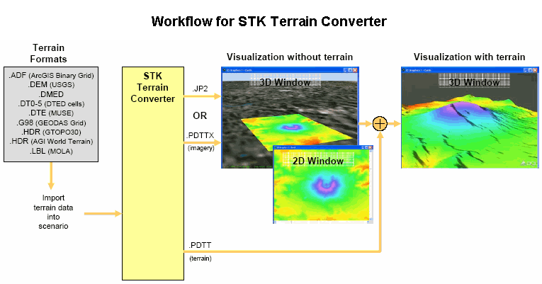
To view a diagram of the Terrain Converter's workflow (opens in a separate window), click here.
For a list of terrain formats that can be converted by the Create Color Elevation Imagery utility, see Terrain Sources.
To add the converted files (.jp2, .bmp, or .ppm) to the 2D Graphics window, use the Images properties page or drag and drop the files from the file browser to the 2D Graphics window.
To add the converted files (.jp2 or .pdtt) to the 3D Graphics window, use the Globe Manager or drag and drop the files from the file browser to the 3D Graphics window.
Terrain Region
Central Body. Associates the terrain region with the central body specified here.
South Lat, West Lon, North Lat, East Lon. Specifies the coordinates for the region containing the terrain to be converted. STK uses any valid terrain sets included in the selected region. If more than one terrain set is valid for a region, STK uses the terrain set with the highest resolution of available terrain sets. If the region contains no terrain data, the image will not be created.
Select On 2D Map. If enabled, click and drag the mouse in the 2D Graphics window to select a terrain region. The South Lat, West Lon, North Lat, and East Lon fields are automatically updated with the coordinates of the selected region.
Get Min/Max Alt button. Click to display the minimum and maximum altitude values of the region selected in the 2D Graphics window.
The minimum and maximum altitudes displayed are estimated based on the selected region for speed reasons. When the region is actually converted, the minimum and maximum values will be updated with the true values.
Color Options
Color Input Method. Specifies the format of the input color:
HSV. (Hue, saturation, value.) HSV is the recommended input method for terrain conversion because it produces a wider range of colors than RGB. Valid values: 0 through 1.0.
RGB. RGB provides a smooth ramp that fades from the minimum color to the maximum color. RGB is not recommended for terrain conversion because it does not provide as much detail as HSV. Valid values: 0 through 255.
Altitudes From. Specifies whether altitude is referenced from mean sea level (MSL) or the central body's reference ellipsoid (WGS84).
Smooth Colors Over Altitude. If selected, a color will smoothly graduate to the next color. If not selected, no interpolation is done.
Input Altitude Colors. Specifies either:
Color Ramp. Set HSV or RGB for the rendering of elevation data during the conversion process. The resulting image is colored so that elevations are drawn with a linearly interpolated color between the minimum altitude and the maximum altitude, depending on the elevation
The default values for Hue, Saturation, and Value will display dark blue at the lowest altitude, green at the mid-point, and white at the highest altitude.
Explicit. Use the Add, Remove, Remove All, and Change buttons to explicitly set the altitude for specific HSV or RGB values used during the conversion process. All elevation colors are linearly interpolated between the specified altitudes.
Altitude. The minimum and maximum altitudes between which colors are interpolated. Use only for color ramps when the Use Min/Max Colors at Min/Max Altitudes of Selected Region is enabled.
Hue. Gradation of the color.
Saturation. Intensity of the color.
Value. Brightness of the color.
Use Min/Max Colors at Min/Max Altitudes of Selected Region. If selected, uses the minimum and maximum altitudes within the terrain region as the bounds to linearly interpolate all colors across the color ramp depending on the altitude of a position. If not selected, you can manually enter the minimum and maximum altitudes as the bounds for the minimum and maximum colors for the color ramp.
If you have several different terrain regions and want a consistent color scheme for all of them, manually enter the same minimum and maximum altitudes for each region of terrain. The range must be wide enough to handle the highest and lowest points from all of the terrain regions to ensure that a green pixel on one block of terrain was at the same altitude as the same color green pixel on another block of terrain.
Output File
Specifies the type of file to be created during the conversion and where it will be stored.
Format. Converts and saves the image to the specified file format. Use the .pdttx, and .jp2 formats for the 3D Graphics window and the .bmp, .ppm, and .jp2 formats for the 2D Graphics window. To also create a pdtt file for the .jp2 or. pdttx format, select Create a pdtt file for the selected region.
Size Options
The pixel size of the image files to be created. The default size is 1024X1024. The default is recommended when the terrain resolution is to be down-sampled. To choose another standard or custom size, use the drop-down menu to the right of the field. If you select Custom from the drop-down menu, enter the Width and Height in the text boxes to the right of the field.
Directory. Specify a directory or use the  button to choose the directory in which the converted image is stored.
Filename. The name of the file to create based on terrain data.
Convert button. Click to create an image file named <OriginalFileName>_<Size>.<Extension>. For instance, if you created a 1024X1024 and 512X512 JP2 file named Florida, the resulting files would be named FLORIDA_1024.jp2 and FLORIDA_512.jp2.
Creating .pdttx and .pdtt files may take a long time depending on the resolution of the terrain set used and size of the region selected.