Azimuth-Elevation Mask File Format (*.aem)
An azimuth-elevation (Az-El) mask file is an ASCII text file that is formatted for compatibility with STK and ends in an .aem extension. Azimuth-elevation mask files can be useful when you need to provide STK with data for a facility, place, target, or sensor to model certain unique circumstances. In order for an Az-El file to be formatted correctly, it must contain the following elements:
Keywords used in every az-el mask file
Azimuth values must be in sequential order in an AzEl mask file.
| Keywords | Description |
|---|---|
| stk.v.<major release number>.<minor release number> | Enter the version of STK software for which the file is formatted to be used. You can create files in and import them into STK software versions consistent with this file version stamp or higher. For example, if you create a file in and stamped it with stk.v.4.0, you can import it into STK software version 4.0 or later. |
| BEGIN AzElMask END AzElMask |
These set off the beginning and end of the azimuth elevation pairs. |
| CoordinateAxes |
(Optional) Defines the reference axes used when interpreting the azimuth and elevation values in the file. This keyword is supported when a sensor uses the file but not when a facility, place, or target uses the file. If you do not provide this, STK uses the Sensor parent's body axes as the reference axes. Supported values are the following:
|
NumberOfPoints
|
Specify the number of azimuth-elevation pairs in the file. For example, if you enter NumberOfPoints 20, you would then include 20 azimuth-elevation pairs. This entry must precede the actual paired data. |
| BEGIN AzElMaskData | Signifies the beginning of the azimuth-elevation data pairs. |
The structure of a generic azimuth-elevation mask file looks something like this:
Generic azimuth-elevation mask file structure
stk.v.6.0
BEGIN AzElMask
NumberOfPoints x
BEGIN AzElMaskData
.
.
.
END AzElMask
Data points following the BEGIN AzElMaskData keyword are in the following format:
<Azimuth> <Elevation> - The data in an external azimuth-elevation file should start at zero azimuth and go to an azimuth of 360 degrees. Elevation values can range from -90 degrees to 90 degrees.
Sample azimuth-elevation mask file format
stk.v.6.0
BEGIN AzElMask
NumberOfPoints 67
BEGIN AzElMaskData
0.0 5.0
5.0 5.0
6.0 6.0
7.0 7.0
8.0 8.0
9.0 9.0
10.0 10.0
11.0 9.0
12.0 8.0
13.0 7.0
14.0 6.0
15.0 5.0
20.0 5.0
25.0 5.0
27.5 7.5
.
.
.
267.5 22.5
270.0 25.0
272.5 22.5
275.0 20.0
277.5 17.5
280.0 15.0
290.0 5.0
300.0 5.0
310.0 5.0
320.0 5.0
330.0 5.0
340.0 5.0
350.0 5.0
360.0 5.0
END AzElMask
STK-generated Az-El Mask Files
STK generates Az-El mask files if you set the Use option to Terrain Data on the AzElMask properties page for a facility.
When you save the scenario, STK creates the AEM file automatically. In addition to the AzEl angles, STK computes intermediate angles between the facility and the horizon; this is useful if you have vehicles in the local area.
These STK-generated AEM files use a different format, as described below.
Several additional keywords are available at the start of the file.
| Keyword | Description |
|---|---|
| FullMask | Indicates that this file contains a range-dependent Az-El mask definition. |
| MaxRange | Specify the maximum range from the origin of the mask to a rise in the elevation angle of the obscura. |
| Latitude Longitude Altitude |
Specify the geodetic origin of the mask. |
| MeasureAzOnSurface | A value of Yes turns on algorithmic control specifying that the azimuth to the target object be measured as the azimuth to the target object subpoint. |
The data section for a range-dependent mask is different as well in the STK-generated Az-El mask file. Azimuth-specific data groupings are defined by a header line giving the following:
- the azimuth in degrees
- the maximum elevation required along that azimuth to avoid masking*
- the number of increases in elevation along that azimuth direction
The rest of the azimuth-specific block, on subsequent lines, lists pairs of elevation angles and slant ranges where the listed elevation is required to avoid masking beyond the listed slant range**. The number of azimuth-specific blocks is given by the NumberOfPoints keyword.
* The maximum elevation value will be the value used when considering ranges greater than the MaxRange specified in the above keywords. This data should be repeated as the last elevation/slant range pair.
** The elevation angle used between the origin and the first slant range value will be either zero or -90 deg, depending on the sign of the first elevation.
An example of an Az-El mask file generated by STK follows.
FullMask
NumPoints 360
MaxRange 167738.33
Latitude 34.01337793
Longitude 88.98876355
Altitude 5395.537
MeasureAzOnSurface Yes
Begin AzElMaskData
0.000000 -0.619831 69
-3.460317 26.105634
-3.313065 1865.565959
-3.003138 2171.493050
-2.754905 2477.436636
-2.559098 2783.411338
-2.402351 3089.412186
-2.299040 3395.490242
-2.217928 3701.589422
-2.149417 4007.694724
-2.031639 4313.647414
-1.915944 4619.579840
-1.814792 4925.529046
-1.781652 5231.644461
-1.767369 5537.804607
.
.
.
1.000000 -0.587503 70
-3.450429 26.104450
-3.418777 332.717060
-3.277980 1865.497974
-2.967135 2171.419816
-2.718380 2477.359214
-2.522106 2783.329840
-2.364900 3089.326558
-2.266702 3395.412313
-2.191975 3701.523287
-2.129859 4007.641920
.
.
.
The format of the STK-generated file is:
- The file has 360 groups of data, one for each degree in azimuth.
- The first line in every group has three columns:
- Column 1 = Azimuth from the North toward the East (in degrees)
- Column 2 = Elevation from the local horizontal toward the local zenith (in degrees)
- Column 3 = Lines of additional intermediate data for the group
- The subsequent lines in every group have two columns:
- Column 1 = Elevation from the facility toward an intermediate point (in degrees)
- Column 2 = Radial distance from the facility to where the elevation intersects the terrain (in meters)
Graphical representation of an azimuth/elevation mask definition
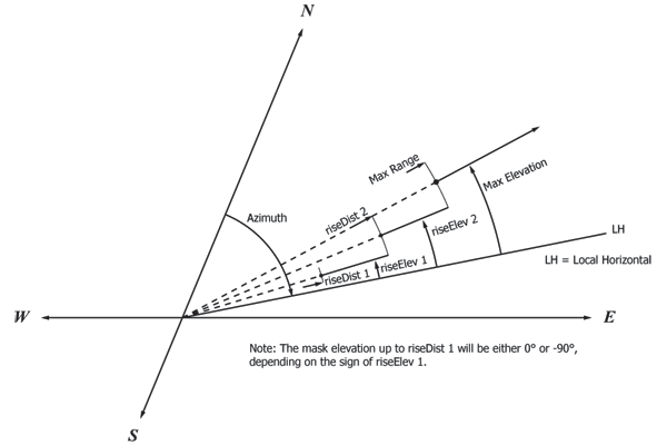
This is a simple example showing use of different elevation constraints to objects in three range regimes. The max range, 20,000 km, is repeated for each azimuth entry, along with the max elevation, 22.2 deg. In this example, within 5000 km of the facility, the minimum elevation is 6.6 deg; between 5000 and 20,000 km, the minimum elevation is 11.1 deg, and beyond 20,000 km the elevation is 22.2 deg.
stk.v.8.0
BEGIN AzElMask
FullMask
NumberOfPoints 3
MaxRange 20000000.0
BEGIN AzElMaskData
0.0 22.2 3
6.60 1.0
11.10 5000000.0
22.2 20000000.0
180.0 22.2 3
6.60 1.0
11.10 5000000.0
22.2 20000000.0
360.0 22.2 3
6.60 1.0
11.10 5000000.0
22.2 20000000.0
END AzElMask