Free Space Loss | Atmospheric Loss Models | Urban and Terrestrial Models | System Temperature | Antenna Temperature | Refraction Models
Environmental & Loss Factors
Free Space Loss
Free space loss is given by:
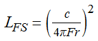
where:
LFS is free space loss (in linear units)
c is the speed of light. The value used in STK is 2.99792458e08 m/s.
F is transmitter output frequency.
r is range between the transmitter and receiver.
Atmospheric Loss Models (Atmospheric Absorption Models)
There are currently four atmospheric absorption models included in STK. These models include:
ITU-R P.676-5
TIREM 3.31
Simple Satcom
Script Plugin
Simple Satcom Model
This atmospheric absorption model used in the Communications and Radar modules is valid over the frequency range from 1 GHz to 350 GHz. Signals operating at frequencies outside this range will have no attenuation. This model is only applicable between the altitude of 20km to 100km. If the signal between a Transmitter or Receiver is not within this altitude range, no attenuation will occur. Use of this model is dependent on two factors:
- Is the model enabled at the scenario level (using the option on the RF Environment page)?
- Does the signal actually pass through the atmosphere?
The gaseous absorption loss LGA (in dB units) is then computed as follows:
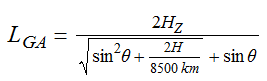
where:
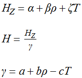
, b,
, β, ζ are the frequency-dependent model coefficients. The exact values used in the equations are determined using logarithmic interpolation based on the transmitter frequency. The table of raw values is found in the data file GACoeff.dat in the directory
<STK install folder>/STKData/CentralBodies/Earth/Rf.These values in this file may be changed by the user if desired.T is the surface air temperature in degrees C. Obtained from the receiver or transmitter's parent object from the value specified on the Atmosphere page.ρ is the surface water vapor concentration (g/m3).θ is the local elevation angle from a ground station to a satellite.
In the case of satellite-to-satellite communication at very low grazing altitudes, the signal passes through the atmosphere; the Simple Satcom model WILL attenuate the signal.
Ippolito, Louis J., Jr., Radiowave Propagation in Satellite Communications , New York: Van Nostrand Reinhold (1986), Ch. 3.
Urban and Terrestrial Models
There are currently two Urban and Terrestrial models included in STK. These models include:
Two Ray
Urban Propagation Wireless InSite RT
Two Ray (Fourth Power Law) Model
This propagation model is applicable to short-range and low antenna heights for the transmitter and the receiver antennas. The situation may arise where the receiving antenna may experience a destructive ground reflection in addition to the LOS transmission.
If the Transmitter or Receiver has an height above ground greater than 300m, a loss will not be computed.
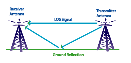
The total propagation loss (free space and two ray destructive signal loss) may be approximated by the well known "fourth power law" model. The portion describing the two ray destructive signal loss is computed according to the following equation:
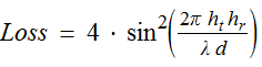
where
λ is the wavelength.
d is the link range.
ht is the height of the transmitter above ground.
hr is the height of the receiver above ground.
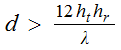
Satisfying the following condition will ensure the validity of the model. If this condition is not satisfied, a warning indicating that the loss was not computed is displayed in the message viewer.
STK computes the free space and the two ray components separately and reports them independently under the free space and atmospheric loss columns in the Link Budget reports.
The sum of the free space loss and the two ray components constitute the "fourth power law" loss.
System Temperature
System temperature is defined as
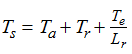
where
Ta = antenna temperature (defined below)
Tr = Ttr (1/Lr - 1), whereTtr = receiver transmission line temp. (290 K default), andLr = receiver transmission line loss (user input, in linear units),
Te = To (Fn - 1), whereT0 = reference noise temperature of 290 K, andFn = receiver noise figure (user input, in linear units), and
Lr = receiver transmission line loss (user input, in linear units)
System and antenna noise temperature are affected significantly by antenna polarization.
Antenna Temperature
Antenna temperature is defined as
Ta = TExternal + TSun + TRain (ground-based objects), or
Ta = TSky + TGround + TSun + Train + Tcosmic +Tother (all other objects), where
Texternal = F(θ) , whereF(θ) is the interpolated antenna noise temperature as a function of the elevation angle based on user supplied external data. Third order Lagrange interpolation is performed. If the elevation angle is outside the range supplied by the user the closest value will be used,
where
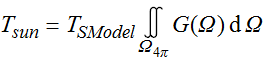
TSModel is the Sun noise temperature as calculated by the Sun model. The model is defined over the frequency range from 140 MHz to 100 GHz and can be calculated using:
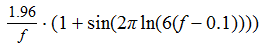 wheref = frequency in GHz, and
= integrated antenna gain over region intersected by Sun or Earth,
TRain = T (1 - LRain) , where
T = surface temperature in Kelvin, and
Lrain = rain loss (in linear units),
Tsky = T (1 - LGA ), where
LGA = gaseous absorption loss (in linear units),
Tground is defined analogously to Tsun
Tcosmic = 2.7 K, and
Tother = user provided value.
Maral, G., and M. Bousquet, Satellite Communications Systems: Systems, Techniques and Technology , 2nd ed., Chichester: Wiley (1993), sec. 8.3.3.1.
Refraction Models
The following constants and equations relate to refracted elevation and Line of Sight constraints.
ITU Refraction Model
The ITU Refracted Elevation model is based on International Telecommunications Union Recommendation 834-4 (2003), equations (12-14). For the Refracted Line of Light constraint, the refracted elevation to the horizon is computed via equations (8-11) of the same ITU Recommendation. For elevation angles below the horizon, the refracted Line of Sight access constraint employs the unrefracted elevation angle to compute the range to the Earth. If the target range is less than this value, the constraint is satisfied.
4/3 Earth Radius Method
The 4/3 Earth Effective Radius method defines the refracted elevation angle θref as
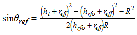
where
ht = altitude of the target,
reff = 4/3 earth radius below the RF (comm or radar) object,
hrfo = altitude of the RF object, and
R = RF object-target range
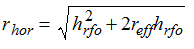
For the Line of Sight constraint, the refracted range to the horizon rhor is calculated via trigonometry of right triangles:
The refracted elevation angle of the horizon θhor is computed as
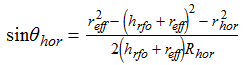
If θref > θhor , line of sight exists, and the constraint is satisfied. If θref < θhor and R < Rhor, compute the range to the ground Rg at θref. If Rg > R , the constraint is satisfied.
 Visit AGI.com