Analyzing Potential Satellite Conjunctions
STK Premium (Space), or STK Enterprise
You can obtain the necessary licenses for this training by contacting AGI Support at support@agi.com or 1-800-924-7244.
The results of the tutorial may vary depending on the user settings and data enabled (online operations, terrain server, dynamic Earth data, etc.). It is acceptable to have different results.
Capabilities Covered
This lesson covers the following STK Capabilities:
- STK Pro
- Conjunction Analysis Tool
Problem Statement
In order to keep your satellites safe, you need to analyze any possible conjunctions with other satellites.
Solution
Use STK's Conjunction Analysis capability (CAT) to analyze any possible conjunctions with other satellites. This exercise will give you the opportunity to practice the following skills:
- Use Launch Window Analysis Tool (LaunchCAT) to determine limitations on your launch window.
- Use Advanced CAT (AdvCAT) to analyze close approach to your satellites.
- Use LaserCAT to analyze potential secondary objects affected by laser ranging.
Create a New Scenario
All STK analysis begins with a scenario. You will be analyzing a launch starting today for the next seven (7) days.
- Click the Create a New Scenario button.
- Enter the following in the New Scenario Wizard:
- When you finish, click OK.
- When the scenario loads, click Save (
 ).
).
| Option | Value |
|---|---|
| Name | CAT |
| Description | Can I Analyze All Potential Conjunctions with Other Satellites? |
| Location | C:\Users\<username>\Documents\STK 12\ |
| Start | Today |
| End | + 7 days |
LaunchCAT
Starting with the launch of a satellite, it is important to analyze any possible conjunctions that may restrict the launch window. The Launch Window Analysis tool computes the launch times during which close approaches with other objects violate a minimum range constraint.
Model the Launch Vehicle
- Extend the Insert menu.
- Select the Default Object... option.
- Select the Launch Vehicle (
 ).
). - Click the Insert... button.
Propagate the Launch Vehicle
- Open up the Launch Vehicle's () properties (
 ). We will keep the default settings.
 - Click OK to ensure the Launch Vehicle is propagated. Also note the trajectory of the new LaunchVehicle is out of Kennedy Space Center towards the east.
Update the Satellite Database
This portion of the exercise requires an internet connection. If you do not have an internet connection, you can skip this section.
You should update your satellite database to ensure you are using the most accurate satellite positional data. You can do that now.
- Extend the Utilities menu.
- Select the Data Update... option.
- Ensure the AstroData tab is selected.
- Ensure the Update option is enabled for the Satellite Database.
- Click the Update Now button.
- Click OK.
Launch Window Analysis Tool
- Right-click on the Launch Vehicle in the Object Browser.
- Extend the Launch Vehicle menu and select Launch Window.
- Change the Launch Window Interval to cover the entire AnalysisInterval of the scenario.
- Increase the MaxRange to ten (10) km. We want to know the times during which another object comes within ten (10) km of the LaunchVehicle.
- Compute the results.
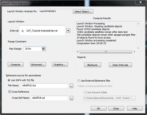
The Compute Results windows shows you the possible collisions that limit your launch window. Your exact results could differ from the ones above depending on the date your TLEs were generated and the scenario interval. If the results show "No objects found to have access," try increasing your max range constraint and re-computing the conjunctions so you have sample results to examine.
Take a look at the Blackouts report. The report displays the launch times that result in conjunctions, as well as, which objects have a conjunction.
AdvCAT
The Advanced CAT tool provides a convenient way for you to carry out close approach analysis for multiple satellites and two-line elements (TLE) sets. After applying your selected filters, Advanced CAT performs close approach analyses between primary objects (e.g. satellites owned by or otherwise of interest to you) and secondary objects (e.g. those presenting a risk of collision), with reference to a threshold -- a minimum acceptable distance -- between the ellipsoidal threat volumes of the objects.
Model the International Space Station
In this exercise, you will analyze close approaches to the International Space Station (ISS). You will insert the ISS using the Standard Object Database.
- Launch the Insert Objects (
 ) tool.
 - Select Satellite as the Object to be Inserted and From Standard Object Database as the Method.
- When the Standard Object Database appears, search for the ISS.
- Select the ISS entry with the Common Name ISS and the SSC number of 25544.
- Click Insert.
- Close the Standard Object Database.
It is possible that you will have multiple options. If you are connected to the AGI database, select the ISS entry from the AGI Standard Object Data Service data source; otherwise select one from the Local Database.
Add an AdvCAT Object
- Insert a new AdvCAT (
 ).
). - Double-click the AdvCAT () object in the Object Browser to open its properties ().
- Select the Basic - Main page.
Set the Primary and Secondary Objects
Primary objects are the satellites of interest to you, such as those that you own or wish to use. Secondary objects are those that present a potential risk of collision with, or unacceptably close approach to, your primary objects. The Primary and Secondary List panes display available objects or TLE sets from which objects can be selected.
- In the Primary List, move the Iss_25544.sa to the Chosen objects field.
- In the Secondary List, move stkAllTLE.tce to the Chosen objects field.
- What is the date on the stkAllTLE database?
- Ensure the threat volume values for both the primary and secondary objects are:
- Ensure the Use Range Measure option is disabled.
- Click Apply.
| Option | Value |
|---|---|
| Tangential | 20 km |
| Cross-Track | 10 km |
| Normal Threat Volume | 5 km |
These values are significantly larger than the values used in the first conjunction analysis. The larger values will increase your chance of identifying a conjunction. Expanding the threat volume for your Primary satellite will also increase your chances of identifying a close approach.
You are asking STK to perform a large number of calculations, some of which common sense tells us are unnecessary. For example, in what type of orbit is your primary satellite? Does it really make sense for STK to propagate TLEs and range calculations for any of the satellites that are outside of that range? Of course not! There is no danger of a conjunction between a LEO and a GEO.
Using Pre-Filters
The basic idea behind close approach processing is to start with all cataloged orbiting objects and efficiently eliminate members of the population that do not come within the specified distance of the reference object. The basic approach consists of first eliminating as many members of the population as possible via geometric properties, which takes considerably less time than fully propagating these satellites and then computing close approaches. The final determination of the existence of close approaches is always done by sampling the ephemeris of the candidate and reference objects, but some set of pre-filters is usually applied to limit the amount of ephemeris generation that is required.
Several pre-filters are available as part of close approach processing. These filters are computationally inexpensive methods for limiting the number of objects and the periods of time for which brute force searching is needed. The proper use of the pre-filters can greatly reduce the amount of time needed for close approach processing. In this example, you will use all four of the available pre-filters.
- Select the Basic - Advanced page.
- Locate the Pre Filter options.
- Take a moment to review the available pre-filters.
- Set the following:
- Click Apply.
| Filter | Description |
|---|---|
| Out of Date Filter | Allows you to determine how the Conjunction Analysis capability will handle two-line element sets with epoch dates that do not fall within the time period chosen for the close approach analysis |
| Apogee/Perigee Filter | Used to eliminate candidate close approach objects having a range of altitude that does not overlap with that of the reference object. |
| Orbit Path Filter | Used to eliminate any candidate object whose orbital path does not come within a specified distance of the orbital path of the reference satellite. |
| Time Filter | Works in two stages. Stage one determines when each candidate satellite will be within a specified distance of the path (not the position on the path) of the reference satellite and vice versa. Stage two determines the overlaps of these intervals. Any candidate satellite at the same time that the reference satellite is close to the candidate’s trajectory is eliminated. |
| Filter | State | Value |
|---|---|---|
| Out of Date TLE | On | 15 days |
| Apogee/Perigee | On | Accept Default |
| Orbit Path | On | Accept Default |
| Time | On | Accept Default |
Now, in addition to the filters described above, TLEs older than fifteen days will be considered inaccurate and eliminated from the analysis.
Display Ellipsoids
Possible close approaches haven't been computed yet. Let's set one final property before you do. This setting will allow you to see the ellipsoids for all the secondary objects included in your scenario. This gives you an idea of just how crowded it is "up there."
- Select the 3D Graphics - Attributes page.
- Enable the Show Secondary Ellipsoids option.
- Enable the All option.
- Click Apply.
Compute!
Since your analysis will be considering a lot of different close approaches, it could take some time to compute. Let's enable the option that displays a message box when close approach computation is completed.
- Select the Basic - Main page.
- Enable the Display Acknowledgment when done option.
- Click Compute. This will take a few minutes.
- Click OK.
Report Close Approaches
- Select AdvCAT () in the Object Browser.
- Open the Report & Graph Manager (
 ).
). - Click Generate.
- Use the report to answer the following questions:
- What was the span of ranges of the conjunctions?
- The report includes both minimum separation and minimum range. What is the difference?
| Option | Value |
|---|---|
| Object Type | Adv CAT |
| Object (Below Object Type) | Adv CAT |
| Show Reports | On |
| Show Graphs | Off |
| Style | Close Approach by Min Range |
| Generate as | Report/Graph |
View Conjunction in 3D
Let's look at one of your conjunctions. Since different TLEs result in different conjunctions, your results may vary.
- Zoom To the ISS in the 3D Graphics window.
- Bring the Close Approach By Min Range report to the front.
- Right-click on the Start Time of one of the conjunctions.
- Extend the Time In menu.
- Select the Set Animation Time option.
- Bring the 3D Graphics window to the front.
- Step Forward (
 ) or Step in Reverse (
 ) as necessary to watch the ellipsoids approach and then intersect each other.
When You Finish
- Close the report.
- Close the Report & Graph Manager ().
The Big Picture
After analyzing a conjunction close up, let’s look at the big picture. You want to see all of the objects you initially considered in your analysis (this will include those objects which were eventually eliminated by your filters).
- Bring the 3D Graphics window to the front.
- Reset (
 ) the animation.
 - Be sure to zoom out far enough that you can clearly see the geostationary belt.
- Increase the Time Step (
 ).
). - Play (
 ) the animation.
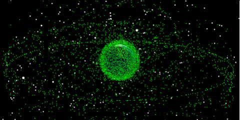
Wow! That is a busy scene! This view gives you an idea of what is up there. Of course, keep in mind that each green ellipsoid you are seeing is magnitude larger than the object inside it. Still, space is a busy place!
LaserCAT
A variety of commercial and military operations involve the laser illumination of a satellite, missile or launch vehicle from an Earth-based site. Such an illumination, known as a lasing, may be used to provide precise range information or carry out data transfers to other satellites or ground facilities. However, the lasing can pose a serious threat to other satellites. For example, sensitive satellite sensors can be damaged or even destroyed if inadvertently illuminated. The LaserCAT tool is designed to assess the potential of an unintended illumination of a satellite during a given lasing run or within a given lasing window.
- Insert a Facility (
 ). This is the Laser tracking site. For this analysis, we will have to have access to the ISS. If you move the facility away from the default location, make sure it is between +/- 50 degree latitude.
 - Right-click on the facility.
- Extend the Facility menu and select LaserCAT.
- Select the ISS as the Target Object.
- Take a look at the other properties.
- We are evaluating any possible conjunctions with the entire satellite database. You could probably restrict this to only the active satellites and exclude the inactive ones and debris to reduce the number of objects you are concerned about.
- Keep the default values for the Laser properties for now. You are looking for potential objects up to five (5) degrees away from the Facility-ISS vector, up to 500,000 km range.
- Your analysis should cover the entire scenario time interval.
- Compute the analysis.
- Open the Clear Firing... and Potential Victims... report to see the intervals when you can safely track the ISS from the facility. You will also see the intervals when you could accidentally hit another object.
When You Finish
- Save () your scenario.
- Close STK (
 ).
).