External Ephemeris
The External Ephemeris procedure enables you to load an external ephemeris file and create a trajectory based on it. You can then apply attitude, aerodynamics, propulsion, and thermal models to the external ephemeris trajectories.
Loading an External Ephemeris File into Aviator
To load an external ephemeris file into Aviator:
-
Add an aircraft to your scenario and choose Reference State in the Site Properties window.
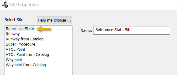
This inserts a Reference State site at the beginning of the mission to define existing flight conditions. - Enter a name for the site.
- Click Next.
-
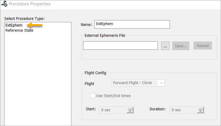
Ensure that ExtEphem is selected in the left panel of the Procedure Properties window.
External Ephemeris Properties
The table below describes the available fields when loading an external ephemeris file.
| Field | Description |
|---|---|
| Name | Enter a name for the procedure. |
| External Ephemeris File | Click  to locate and load an external ephemeris file. Clicking Save... enables you to save the ephemeris file. Clicking Reload reloads the file into the procedure. to locate and load an external ephemeris file. Clicking Save... enables you to save the ephemeris file. Clicking Reload reloads the file into the procedure. |
| Flight |
Choose a flight type from the drop-down that describes the current attitude of the aircraft across the designated time period. Options include:
Weight on Wheels refers to the period during take off and landing when the aircraft's wheels are on the ground, meaning the aircraft does not have a pitch.
Before setting the flight mode, make sure the currently selected aircraft can support this flight mode. For example, a missile object does not have a takeoff or landing performance model so the takeoff and landing flight modes cannot be used for this object.
|
| Use Start/End Times | Select this box if you wish to define start and end times for the procedure. |
| Start | Define the start time for the flight mode. This field is only available when the Use Start/End Times box is selected. |
| Duration | Define the duration of the flight mode. This field is only available when the Use Start/End Times box is selected. |
Shift/Rotate
The Shift/Rotate option allows you to move a given external ephemeris file to any point on the Earth. You can also change the direction or shift the altitude. This feature is only available to the initial external ephemeris procedure in a mission.
| Field | Description |
|---|---|
| Shift Time | Allows you to shift the external ephemeris procedure so that the aircraft is at the specified position values at the specified elapsed time. |
| Latitude | Allows you to set the latitude of the external ephemeris at the specified shift time. |
| Longitude | Allows you to set the longitude of the external ephemeris the specified shift time. |
| Altitude | Allows you to set the altitude of the external ephemeris at the specified shift time. |
| Course | Allows you to set the desired course of the external ephemeris at the specified shift time. |
There are a few additional options or parameters you can set or change based on the drop-down menus beside the fields in the Shift/Rotate option.
| Field | Description |
|---|---|
| Set | This button is beside the Shift Time option and allows you to populate the lat/lon/alt with the point along the trajectory at a given shift time. |
| Relative/Waypoint | This button is beside the Latitude option and allows you load coordinates from a catalog (waypoint) or shift a point (i.e. shift a point down a runway by a half nautical mile). |
| Altitude: Relative/WGS84/MSL | This button is beside the Longitude option and allows you to set the altitude to be absolute (in various datum) or relative offsets (to the given shift time ephemeris point). |
| Course: Magnetic/True/Relative | This button is beside the Altitude option and allows the specified course to be either absolute or relative to the heading The direction that the aircraft is pointing. at the given shift point. |
Shift and Rotate Ephemeris Example
Here is a quick example of the Shift/Rotate ephemeris:
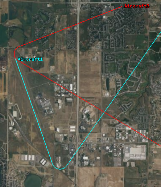
In the image above, Aircraft1 is the non-shifted ephemeris and Aircraft3 is the shifted ephemeris at an animation time of zero (0). You can move from the cyan trajectory to the red trajectory using the External Ephemeris Shift/Rotate capability. In the example, we move the turn in the trajectory over the beginning of the runway and shift the course of the aircraft to be tangent to the runway.
The non-shifted cyan trajectory turns at a time of 95 seconds and the desired tangential course is 150 degrees magnetic. In order to accomplish this shift/rotate, you would input the following in the Shift/Rotate panel:
| Option | Parameter |
|---|---|
| Shift time | 95 seconds |
| Latitude | 40.46227 |
| Longitude | -105.01742 |
| Altitude | 0 Relative |
| Course | 150 magnetic |
If the latitude and longitude of the beginning of the runway/ephemeris is unknown, you can enter zero (0) in the "Shift Time" panel and click "Set...". This sets the latitude and longitude to the position of the ephemeris at zero (0) seconds. Be sure to change it back to 95 seconds or the trajectory will not shift at zero (0) seconds since it is already at the defined latitude and longitude.
Since the latitude and longitude is set to the start of the runway, the trajectory shifts to the point of the ephemeris at 95 seconds to the start of the runway. The relative altitude is zero (0) so the altitude won't change and the course of 150 magnetic rotates the trajectory's course tangent to the runway. This accomplishes the desired transformation.
External Ephemeris Requirements
The table below describes the necessary properties in the external ephemeris file.
| Field | Description |
|---|---|
| Supported file formats | All formats found on this page. |
| Header information | All header information is defined here. |
| Coordinate System |
The ephemeris file needs to be a fixed coordinate system (ECF or Lat/Lon). This includes some of the Analysis Workbench fixed coordinate systems.
|
| Example file | EphemerisLLATimePos Format |