EOIR Clouds
You can choose to show clouds in EOIR and to specify their modeling parameters. Click from the EOIR Configuration window and select the Clouds tab.
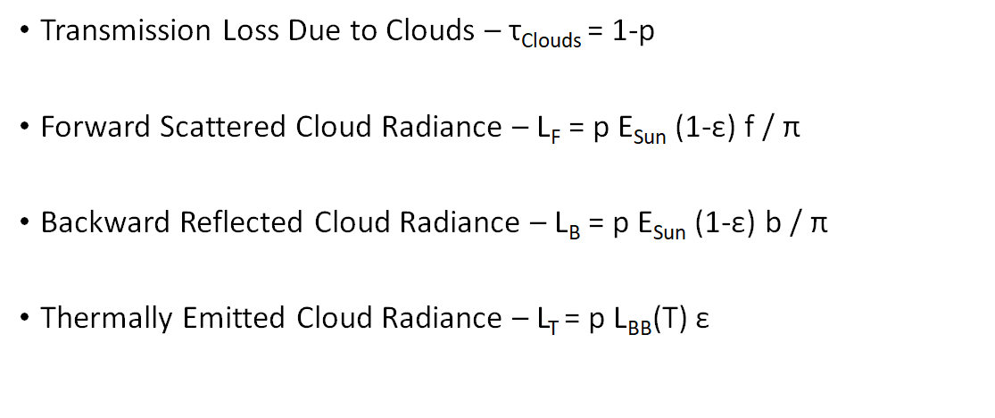
The cloud layer is defined for a single altitude around a celestial body's ellipsoidal shape. You can designate many of the parameters on a latitude/longitude grid. Direct interactions with clouds only occur at the cloud boundary intersections with the sensor paths.
To display clouds, select the Show check box. The Current Datasets panel displays all cloud datasets that are in the scenario. You can add one or more cloud datasets by clicking . To remove a cloud dataset from the list, select it and click .
Select one of the datasets to modify; then you can define the following cloud parameters:
| Parameter | Description |
|---|---|
| Dataset Label | If you are adding a cloud dataset, enter its name in this box. You can also change the name of an existing dataset. |
| Altitude | Specify the height of the cloud layer above the ellipsoidal surface of the central body. The limits are zero (0) km <= Altitude <= 100 km. |
| Forward Scatter | Specify the amount of reflected incident solar illumination scattered to the opposite side of the illumination source. The limits are 0% <= Front Scatter <= 100%. |
| Back Scatter | Specify the amount of reflected incident solar illumination scattered back in the direction of the illumination source. The limits are 0% <= Back Scatter <= 100%. |
Coverage
You can choose either a constant coverage or a file with cloud data.
- For Constant Coverage, setting a percentage will define the percentage of light interacting with the cloud (forward or back scattering). The limits are 0% <= Coverage <= 100%.
- For a file, you can select a clouds-only file (*.csv, *.cld, *.clds) or an image file (*.bmp, *.tif, *.png, *,jpg, *.ppm, *.pgm) to define the cloud coverage. Or, click to download a *.cld file containing cloud data (times and images) that spans the current scenario interval. You can set this file as the cloud coverage file. STK places downloaded cloud files in C:\ProgramData\AGI\STK\STK 13\STKData\VO\Clouds.
Sample CSV cloud files are available in the <install directory>\STK 13\EOIR_Databases\Clouds.
If you define two or more cloud layers that share the same altitude and time period properties, then you may experience undesirable results as STK statistically combines their properties.
You should avoid using cloud files greater than 25 million pixels, as this could overload the EOIR processing.
Radiance or emissivity/temperature
This field enables you to set either a constant value for Radiance or constant values for Emissivity and Temperature.The default is Constant Emissivity and Temperature.
- Constant Radiance: You can set the constant value for Radiance, in W/(cm2 sr um).
- Constant Emissivity and Temperature: You can set the percentage for Emissivity and set the Temperature in degrees Kelvin.
Cloud model outputs