Data Provider Groups | Data Provider Elements
AER Data
Provides azimuth, elevation, and range related information for the relative position vector between the base object and the target object. The information is available in a variety of coordinate axes.
Reference Frames in AER Reports
AER reports for accesses are based on a default local coordinate system for every type of STK object. If the AER Report is based on a sensor, then the coordinate frame of the parent object is used.
For facilities, places, and targets the local coordinate system is LH.
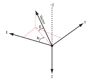
- Azimuth is referenced to X, positive towards Y (clockwise from above).
- Elevation is referenced to X-Y plane, positive along negative Z.
For aircraft, ships, and ground vehicles the local coordinate system is VVLH CBF (Central Body Fixed).
- Azimuth is referenced to X, positive towards Y (clockwise from above).
- Elevation is referenced to X-Y plane, positive along negative Z.
For satellites and missiles the local coordinate system is VVLH CBI (Central Body Inertial).
- Azimuth is referenced to X, positive towards Y.
- Elevation is referenced to X-Y plane, positive along negative Z.
where,
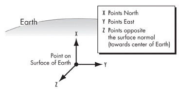
LH (Local Horizontal)
X axis = constrained toward local north
Y axis = local east
Z axis = aligned with local geodetic nadir
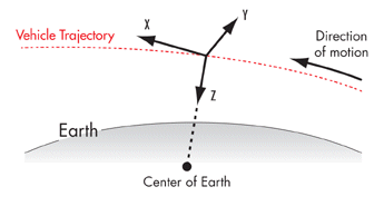
VVLH (Vehicle Velocity, Local Horizontal)
X axis = constrained toward velocity vector
Y axis = perpendicular to X and Z.
Z axis = aligned with geocentric nadir
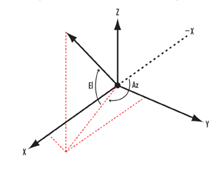
How Azimuth and Elevation are Defined
The following frames are used in defining azimuth (Az) and elevation (El):
Vehicle Velocity Local Horizontal (VVLH) coordinate system
Local Horizontal (LH) coordinate system
Topocentric coordinate system
Topocentric System
VVLH & LH Systems
For more information, see Access Tool.
Available for these objects: Access
Type: Time-varying data.
Availability: Reports | Graphs | Dynamic Displays | Strip Charts
Data Provider Groups
| Name | Description |
|---|---|
| Default | Axes used to express the results by default (i.e., when no specific axes have been chosen by the user). The base object class type determines which axes are used by default. |
| VVLH CBI | Axes aligned with the VVLH axes based on the CBI velocity of the base object. Elevation is measured positive toward the -Z-axis. |
| VVLH CBF | Axes aligned with the VVLH axes based on the CBF velocity of the base object. Elevation is measured positive toward the -Z-axis. |
| BodyFixed | Axes aligned with the body axes of the base object. Elevation is measured positive toward the +Z-axis. |
| NorthEastDown | Axes aligned with North (X), East (Y), and Down (Z) of the detic subpoint of the base object (i.e., the detic projection of the base object's position to its central body's ellipsoid. Elevation is measured positive toward the -Z-axis (i.e, Up). |
Data Provider Elements
| Name | Dimension | Type | Description |
|---|---|---|---|
| Access Number | Unitless | Integer | The number of the current access interval from the list of access intervals. |
| Time | Date | Real Number or Text | Time. |
| Azimuth | Longitude | Real Number or Text | Angle measured from the X-axis of the direction of the relative position vector, positive about the axis used to measure positive elevation. |
| Elevation | Angle | Real Number or Text | Angle measured from the XY-plane to the direction of the relative position vector. |
| Range | Distance | Real Number | Magnitude of the relative position vector. The relative position vector reflects the access settings for light time delay, aberration, and refraction. |
| AzimuthRate | AngleRate | Real Number | The rate of change of azimuth. |
| ElevationRate | AngleRate | Real Number | The rate of change of elevation. |
| RangeRate | Rate | Real Number | The rate of change of range. |
| Path Delay | Time | Real Number | The range divided by the speed of light. |
| From Precision Pass | Unitless | Real Number | The precision pass number of the base object. Applicable only for Satellites. |
| To Precision Pass | Unitless | Real Number | The precision pass number of the target object. Applicable only for Satellites. |
| From Precision Path | Unitless | Real Number | The precision path number of the base object. Applicable only for Satellites. |
| To Precision Path | Unitless | Real Number | The precision path number of the target object. Applicable only for Satellites. |
| Strand Name | Unitless | Text | Lists the names of the objects in the best strand of the stored best strands. The object names are reported as truncated paths, without class names, separated by “to". |
| Local Hour Angle | Angle | Real Number or Text | The local hour angle of the target object with respect to the base object. The local hour angle is the angle from the X-axis of the central body Fixed axes to the projection of the relative position vector into the XY-plane of the central body Fixed axes. |