Access Coordinate Frames
Access calculations compute azimuth, elevation, and range between the primary and associated objects based on the local coordinate system of the primary object. AER reports for accesses are based on a default local coordinate system for every type of STK object for which access is possible. The following table lists the default local coordinate frame for the given objects:
| Objects | Coordinate Frame | Az El Computation |
|---|---|---|
| Facility, Place, Target |
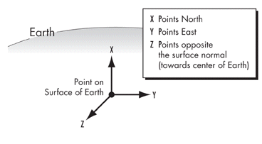
Local Horizontal (LH)
|
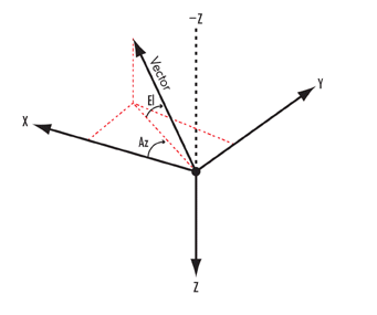
Azimuth is referenced to X, positive toward Y (clockwise from above). Elevation is referenced to the X-Y plane, positive along negative Z. |
| Satellite, Missile, Launch Vehicle |
ECI Vehicle Velocity, Local Horizontal (VVLH)
|
Azimuth is referenced to X, positive toward Y (clockwise from above). Elevation is referenced to the X-Y plane, positive along negative Z. |
| Aircraft, Ship, Ground Vehicle |
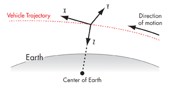
ECF Vehicle Velocity, Local Horizontal (VVLH)
|
Azimuth is referenced to X, positive toward Y. Elevation is referenced to the X-Y plane, positive along negative Z. |
| All other objects | local coordinate system of the object's parent (or grandparent), as applicable | Depends on the coordinate system. |
When using the ECF VVLH frame, if the primary velocity is near zero, STK may switch to the LH frame to avoid an error condition.
Local Horizontal (LH) coordinate system
Vehicle Velocity Local Horizontal (VVLH) coordinate system