Imagery and Terrain Converter
Use the Imagery and Terrain converter to convert a single image, with or without terrain data, into a format that can be displayed in a 3D Graphics window. The image is converted to a pdttx or jp2 file (image inlay) and the terrain data is converted to a pdtt file (terrain inlay).
The Imagery and Terrain Converter is available from the Utilities menu.
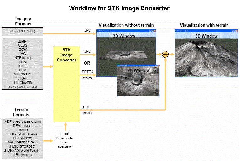
To view a diagram of the Imagery and Terrain Converter's workflow (opens in a separate window), click here.
To display an image inlay or terrain inlay on the central body, use the Globe Manager.
When converting an image with a transparent color to a .pdttx or .jp2 file, the input image must be in a WGS84 geographic projection. If not, STK will re-project the image, which may produce a color that no longer matches the original transparent color. Consequently, areas of the .pdttx file that you may expect to be transparent will not be transparent.
You can also use AgGxChunkImageConverter, which is a stand-alone image converter application, to convert terrain and imagery to .jp2, .pdttx and .pdtt file formats for 3D visualization. This stand-alone executable may be run from the command prompt or may be launched from another application.
Imagery and Terrain Converter Disk Space Usage
The imagery and terrrain converter creates temporary files during the image conversion process and puts them in the output directory or a directory specified by an environment variable. If the drive that holds the temporary files becomes full, the image conversion process fails and returns an error message indicating that STK was unable to create the output file at the desired location. If the image converter fails you can:
- Check the temporary directory drive for sufficient disk space.
- Update your TMP or TEMP environment variable to point to a location with more disk space. STK checks the TMP environment variable first to determine the location to use. If the variable does not exist or is not set, then STK checks the TEMP variable. If that does not exist or is not set, then STK uses the C:\ directory.
Input Data
Image Filename. The image file to be converted. See Valid Image Formats for image files that can be converted using the Image Converter.
Central Body. Associates the image with the central body specified here.
Use Terrain. If enabled, the converter creates a corresponding terrain inlay (.pdtt) for the converted image (.pdttx or .jp2). If you are creating a terrain file, you must specify a terrain source.
Terrain sources can be:
Raw terrain. Any terrain data set specified at the scenario level can be used.
The terrain source used must overlap some region of the image to be converted. Altitudes of zero are inserted wherever the terrain region does not overlap the image.
Processed Intermediate Terrain Files (.datt). The intermediate processed terrain file (.datt) is created whenever a raw terrain source is converted to a terrain file (.pdtt). This intermediate file is deleted in the conversion process unless the Delete Intermediate Terrain File button is disabled. The image converted must fall completely within the selected .datt file.
Use one of the following to select the terrain source:
Automatic Selection. Selects an appropriate terrain source based on the position of the image and available terrain sources. The raw terrain sources are searched first, then any available .datt or .pdtt files.
 Click to add a new terrain source file (.datt). For convenience, all available .datt files in the directory with the selected terrain source files are also added as available sources. Raw terrain sources may be added via the scenario's Terrain properties page.
Extent
South, West, North, East. Specifies the coordinates for the image to be converted.
For *.ntf files, the data in the Extent position fields provides an approximate geographic location and is not intended for analytical purposes (for example, targeting or distance calculation).
Region. Specifies the coordinates for the sub-region of the specified image to be converted.
RGB Transparent Color
Use. Uses the selected RGB color as the transparent color for the image file. All pixels in the image of that color are not displayed.
Output Data
Format. Select either a JPEG 2000 image (jp2) or an AGI image (pdttx).
Directory. Use the button to choose the directory in which converted images should be stored. Once you choose the directory, all images created during the conversion will be placed in that directory. If a terrain file (.pdtt) is created for an image, it is also placed in this directory.
Filename. Name of the converted file.
JPEG 2000 Compression Profile. The compression profile indicates how the image is compressed. The default method is generally acceptable. The two BIIF (Basic Image Interchange Format) profiles were designed for specific NATO and U.S. military applications.
Also, select either Lossless data compression to construct the exact original data from the compressed data or Compression Ratio to construct data that may be different from the original. (Selecting Compression Ratio will produce a much smaller compressed file than Lossless.) If you select Compression Ratio, enter a number indicating the ratio of the compressed file to the uncompressed file.
Terrain File
Use Output Image Data. If selected, stores the converted terrain file in the same directory as the image file and uses the same base file name as the image file. If not selected, you can specify the name of the converted terrain file and the directory in which it will be stored.
Delete Intermediate Terrain File. Deletes the intermediate terrain file (.datt) when the conversion is complete. This option is only available when terrain is generated and the terrain source is a raw data set.
Convert button. Click to convert the selected image file.