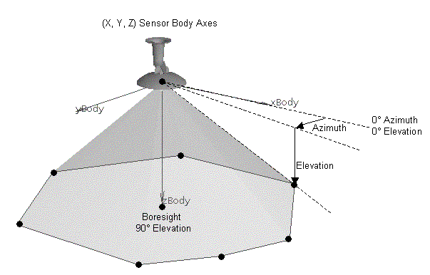
The Az-El Mask Format
Use the format in this topic to create an azimuth-elevation mask to model a sensor's field-of-view limitations. After you create the pattern, you can save it to a pattern file. You can then import the pattern file into STK. STK will read the description contained in the pattern file when the file is referenced by a sensor.
As an example for this topic, you could use the azimuth-elevation mask format to model a sensor with the following specifications:
- The sensor is pointing off the right side of a vehicle with a beam from 40 degrees to 50 degrees off nadir.
- The sensor sweeps forward and aft 30 degrees.
- It is assumed that the vehicle's attitude is such that the vehicle X axis is along the velocity direction, which means that the custom sensor pattern is centered around a vehicle azimuth of 90 degrees.
- The sensor is designed so that the reference direction (boresight) is along nadir and, therefore, is outside of the pattern.
The accuracy of computations performed using custom sensors is directly related to the number of points used to describe the pattern. Interpolated points are automatically added between points with azimuth or elevation differences greater than a specified value (default of 3 degrees); therefore, it is generally better to spend additional time generating a well-defined pattern than to be uncertain of the fidelity of the results.
Definition of the elevation angle
Generate the custom pattern for the example using a polar diagram similar to the one in the reference pane format. The azimuthal angles on the plot now represent azimuth in the facility's or target's local horizon plane with 0 degrees being in the direction of north. The concentric circles on the plot represent elevation angles.
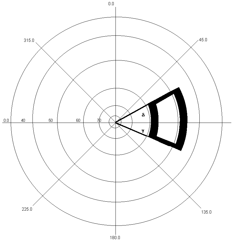
Polar projection for the Az-El Mask format
The angle  = 40 degrees off the boresight becomes the line along the 50 degree elevation contour and the angle
  = 50 degrees off the boresight becomes the line along the 40 degree elevation contour.
You can create the pattern file for this az-el mask format by using the edge points in the polar diagram and making the first and last points the same, to close the pattern.
Az-El Mask Format
| Field | Description |
|---|---|
| NumberPoints | Enter the total number of data points in the file. |
| InterpolateAzElPts |
STK defaults to adding more data points when your existing points are greater than a user-specified angular distance (default of 3 degrees) apart. If this is your choice, you can just leave this field out of the file. To prevent STK from adding interpolated data points, include this field with a value of No. |
| AzElMaskData | Provide the azimuth-elevation pairs. The first point and the last point must be the same so that the sensor pattern is closed. |
| MaxAzElAngleStep | Specifies the maximum angle between points allowed. If the angular distance between two (2) points is greater than this value, STK adds intermediate points by interpolating in az-el space. The default value is 3.0 degrees. |
| EndPatternData |
You must have this keyword at the end of the file. |
Here is the example file for the case described above:
stk.v.12.0
NumberPoints 27
AzElMaskData
60 40
65 40
70 40
75 40
80 40
85 40
90 40
95 40
100 40
105 40
110 40
115 40
120 40
120 50
115 50
110 50
105 50
100 50
95 50
90 50
85 50
80 50
75 50
70 50
65 50
60 50
60 40
EndPatternData