Advanced Constraints
Advanced Constraints allow you to impose a variety of vehicle-specific constraints. You can also opt to exclude time intervals that satisfy a given constraint.
If a constraint is not available for accesses from an object, it will be disabled (grayed out) in the Constraints properties page for that object.The table below describes the advanced constraints and lists the objects that they can be used to constrain access to.
When an access involves a child object (i.e., sensor, transmitter, receiver, antenna, or radar), use the child object's parent or grandparent in the table below to determine whether the constraint can be used for access to that child object. For example, if a constraint can be used for accesses to all vehicles, then that constraint can also be used for any child object of a vehicle.
In the following table, abbreviations in the Constraints used for accesses to... column are:
|
F = facility
|
Pl = place
|
T = target
|
V = all vehicles
|
AT = area target
|
P = planet
|
St = star
|
| Constraint |
Description |
Constraint used for accesses to... |
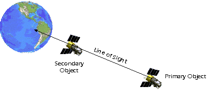
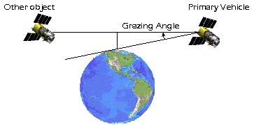
| Grazing Angle |
Describes how high one object appears above the edge of the Earth (or limb) relative to the satellite. Measured relative to the satellite, as the angle between the Earth limb and the other object. This constraint can be used to prevent a sensitive optical sensor, such as those on the Hubble Space Telescope, from aiming too close to the Earth, which might blind the sensor due to reflections off the surface. |
P St V |
|
|
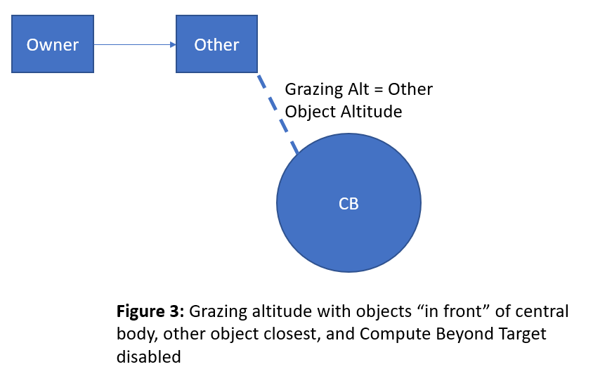
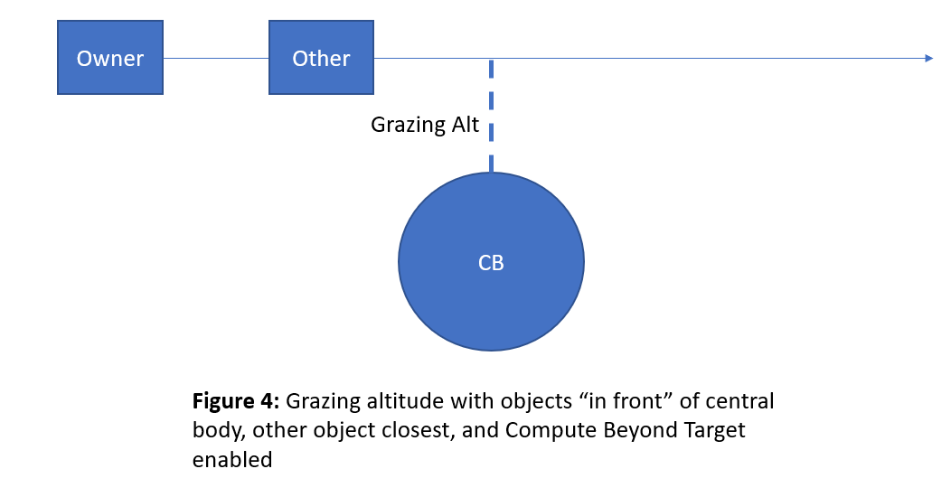
| Grazing Altitude |
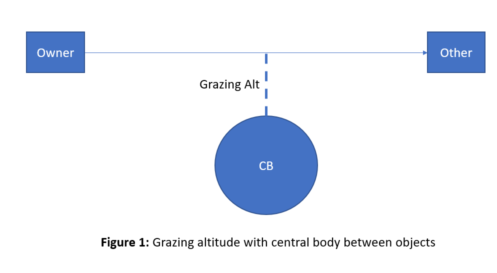
The nearest distance that the line-of-sight between the satellite and the other object comes to the Earth defines the grazing altitude. This constraint can be used to prevent a communications link between the two objects from moving too far down into the atmosphere, which might degrade the quality of the link.
There are two modes of computation for the grazing altitude constraint.
Mode 1: Compute Beyond Target Property disabled
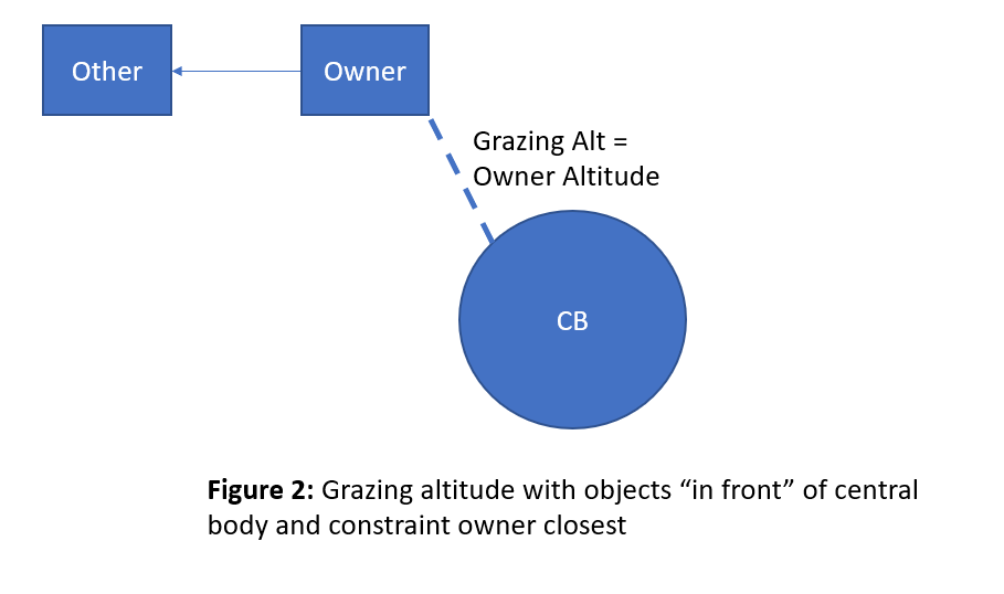
In this mode, the grazing altitude is evaluated strictly along the path between the constraint owner's position and the other object's position. If both objects are "in front" (meaning relative to the center of the Earth) then the constraint will return a value equal to the altitude of the object closer to the earth (see Figure 2 and Figure 3). It does not extend the vector past the other object’s position to see if that results in a smaller grazing altitude. An example of when this might occur is a GEO satellite looking down at a missile launch.
Mode #2: Compute Beyond Target Property enabled
In this mode, the grazing altitude is evaluated along the vector from the constraint owner’s position toward the other object extended past the other object’s position. If both objects are "in front" (meaning relative to the center of the Earth) then the constraint will return one of the following:
- the altitude of the constraint owner if the constraint owner is closer to earth (see Figure 3)
- the grazing altitude calculated beyond the other object’s position if the other object is closer to earth (see Figure 4)
|
P St V |
|
|
|
|
|
|
|
|
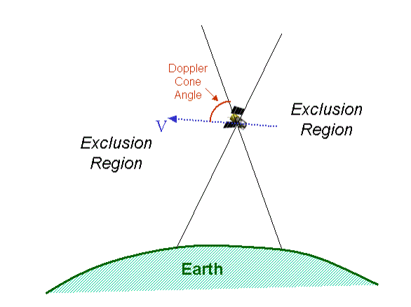
| Doppler Cone Angle |
Measured with respect to the +/- Earth Fixed velocity vector directions. Access within the defined cones is precluded. Typically used to model the collection area for radars. |
F Pl T P St V |
|
|
| Solar Beta Angle |
The solar beta angle is the signed angle of the vector to the Sun relative to the orbital plane. The signed angle is positive when the vector to the Sun is in the direction of the orbit normal. The orbit normal is parallel to the orbital angular momentum vector, which is defined as the cross-product of the inertial position and velocity vectors. |
F Pl T AT P St V |
| Ground Elevation Angle |
Measured with respect to targets, facilities, or area targets. For a target, place or facility, the elevation angle is measured as the angle between the local horizontal and the direction of the satellite. For an area target, the elevation angle is measured as the maximum elevation from any point within an area target. |
F Pl T AT |
| Background |
Constrain access periods based on whether the Earth is or is not in the background. This constraint can be used to limit access from the satellite to another vehicle.
- Space Only - Constrains accesses when only space is in the background of the other object.
- Ground Only - Constrains accesses when only the ground is in the background.
|
V |
| Ground Track |
If ON, constrain access to the Ascending or Descending side of the satellite's ground track. The ascending side of the ground track is defined as the portions of the ground track where the Earth-fixed latitude is increasing. The Earth-fixed latitude decreases on the descending side of the ground track. |
F Pl T AT P St V |