Analyzing Potential Satellite Conjunctions
STK Premium (Space) or STK Enterprise
You can obtain the necessary licenses for this tutorial by contacting AGI Support at support@agi.com or 1-800-924-7244.
The results of the tutorial may vary depending on the user settings and data enabled (online operations, terrain server, dynamic Earth data, etc.). It is acceptable to have different results.
Capabilities covered
This lesson covers the following STK Capabilities:
- STK Pro
- Conjunction Analysis
Problem statement
Engineers, analysts, and operators require a way to simulate launching a satellite into space and to analyze for potential conjunctions with other satellites during the launch. Once the satellite is in orbit, they require a way determine any potential conjunctions with other satellites. Finally, they want to determine when it is safe to illuminate a satellite, missile, or launch vehicle with an Earth-based laser. Since lasing can pose a serious threat to other satellites, they want to assess the potential risk of the accidental illumination of other space objects during a given lasing run or within a given lasing window.
Solution
Use STK's
- Determine limitations on your launch window with the Launch Window Analysis tool.
- Compute close approaches to your satellite with the Advanced CAT (AdvCAT) tool.
- Analyze potential secondary objects affected by laser targeting with the LaserCAT tool.
What you will learn
Upon completion of this tutorial, you will understand:
- The Launch Window Analysis tool
- The Advanced CAT tool
- The LaserCAT tool
Video guidance
Watch the following video. Then follow the steps below, which incorporate the systems and missions you work on (sample inputs provided).
Creating a new scenario
Create a new scenario with a run time of seven days.
- Launch STK (
 ).
). - Click
 Create a Scenario in the Welcome to STK dialog box.
 - Enter the following in the STK New Scenario Wizard:
- Click once you finish.
- Click Save (
 ) when the scenario loads. A folder with the same name as your scenario is created for you.
 - Verify the scenario name and location in the Save As dialog box.
- Click .
| Option | Value |
|---|---|
| Name | CAT_Capabilites |
| Location | Default |
| Start | Today |
| End | + 7 days |
Save (![]() ) often during this lesson!
) often during this lesson!
Adding the Launch Vehicle object to the Insert STK Objects tool
Ensure the Launch Vehicle (![]() ) object appears in the Insert STK Objects tool (
) object appears in the Insert STK Objects tool (![]() ).
).
- Click in the Insert STK Objects tool (
 ).
). - Select the Show item check box for Launch Vehicle in the Object list.
- Click to close the Preferences dialog box.
The Preferences dialog box will open to the
Inserting a Launch Vehicle object
You will simulate a Launch Vehicle that models the properties and behavior of a vehicle that follows an ascent trajectory from a launch point to an orbital insertion point.
- Select Launch Vehicle (
 ) in the Insert STK Objects tool ().
 - Select the Insert Default () method.
- Click .
Selecting the Simple Ascent propagator
Use the simple ascent propagator to define the ascent trajectory from a launch point to an orbital insertion point. The simple ascent propagator creates an ascent trajectory based on launch and insertion parameters. The trajectory is a simple curve rising vertically from the launch pad that turns over smoothly to insert the launch vehicle into orbit with a zero flight path angle at the insertion point using the specified velocity.
- Right-click on LaunchVehicle1 () in the Object Browser.
- Select Properties (
 ).
). - Ensure that Propagator is set to SimpleAscent.
- Click to close the Properties Browser and propagate LaunchVehicle1 ().
You can view the trajectory of LaunchVehicle1 (![]() ) out of Kennedy Space Center, toward the east, in both the 2D and 3D Graphics windows.
) out of Kennedy Space Center, toward the east, in both the 2D and 3D Graphics windows.
Updating the satellite database
This portion of the exercise requires an internet connection. If you do not have an internet connection, you can skip updating the satellite database.
When using the Conjunction Analysis tools, you should update your satellite database to ensure you are using the most accurate satellite positional data.
- Right-click on Open CAT_Capabilities () in the Object Browser.
- Select Properties ().
- Select the Basic - Database page when the Properties Browser opens.
- Click .
- Click in the Update Satellite Database dialog box.
- Click to close the Information dialog box.
- Click to close the Update Satellite Database dialog box.
- Click to close the Properties Browser.
Opening the Launch Window Analysis tool
Use the Launch Window Analysis tool to check an entire launch window for safe and unsafe launch intervals. The Launch Window Analysis tool is a part of STK's Conjunction Analysis (CAT) capability for Launch Vehicles and Missiles. The tool uses a patented solution method to perform the analysis efficiently since potential conjunction events occur over short durations of mere seconds and launch windows are frequently hours long.
- Select LaunchVehicle1 () in the Object Browser.
- Open the LaunchVehicle menu.
- Select Launch Window Analysis....
Using the Launch Window Analysis tool
- Enter 10 km in the Range Constraint - Max Range: field.
- Click .
- Review the data in the Compute Results field.
- Click in the Reports panel.
- Click in the Reports panel.
- Click to close the Launch Window Analysis tool.
- Close all reports.
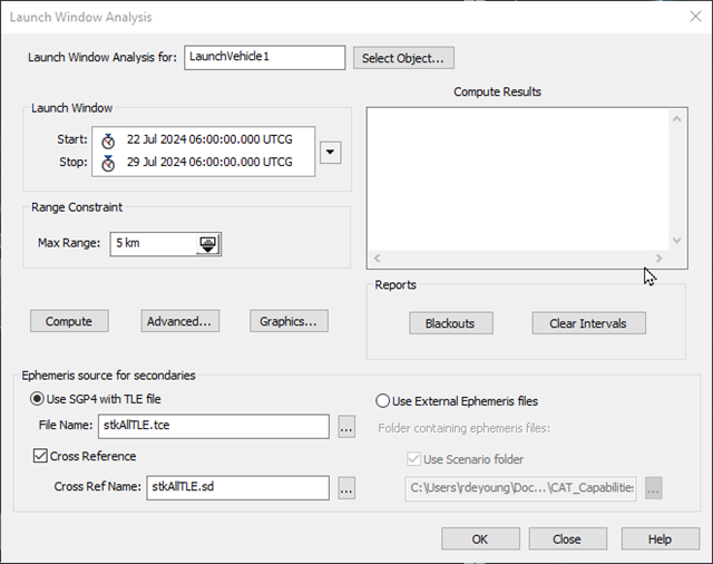
Launch Window Analysis tool
This range corresponds to the minimum allowable distance between the reference object and any other object.
A summary of the results is displayed in the Compute Results field. Be patient. This can take a minute or two.
The Launch Window Blackouts report displays the launch time intervals that result in conjunctions, as well as the objects having a conjunction.
The Launch Window Clear Intervals report displays the launch time intervals where no conjunctions occur.
Inserting a Satellite object
Insert a Satellite (![]() ) object using the Standard Object Database.
) object using the Standard Object Database.
- Select Satellite (
 ) in the Insert STK Objects tool ().
 - Select the From Standard Object Database (
 ) method.
 - Click .
Selecting the International Space Station
You can insert a Satellite (![]() ) object from the online or locally installed Standard Object Databases. USSTRATCOM publishes the database, which contains positional data for thousands of satellites.
) object from the online or locally installed Standard Object Databases. USSTRATCOM publishes the database, which contains positional data for thousands of satellites.
STK supports the use of nine-digit SSC numbers in the GP (General Perturbation) data files. You will use the SSC number associated with the International Space Station (ISS).
- Enter 25544 in the Name or ID: field in the Search Standard Object Data dialog box.
- Click .
- Look at the Common Name column in the Results: list.
- Look at the Data Source column.
-
ISS (ZARYA) is associated with AGI's Standard Object Data Service. If you have an Internet connection, this is a good way to propagate a Satellite (
) object. It will be downloaded into your scenario based on the analysis period you selected using the correct -
ZARYA is associated with the Local Database. This choice uses a TLE stored on your local machine. There is an online database and a locally installed database. It is important that you have updated your local Satellite Database with the correct TLEs when using this choice.
- Select ZARYA in the Common Name column.
- Click . to propagate ZARYA_25544 ().
- Click to close the Search Standard Object Data dialog box.
There are two choices. ISS (ZARYA) and ZARYA.
Adding the AdvCAT object to the Insert STK Objects tool
Ensure the AdvCAT (![]() ) appears in the Insert STK Objects tool (
) appears in the Insert STK Objects tool (![]() ):
):
- Click in the Insert STK Objects tool ().
- Select the Show item check box for AdvCAT in the Object list.
- Click to close the Preferences dialog box.
Inserting an AdvCat object
- Insert an AdvCAT (
 ) object using the Insert Default () method.
 - Open AdvCAT1's () properties ().
- Select the Basic - Main page when the Properties Browser opens.
Using the Advanced CAT tool
Use the Advanced CAT (AdvCAT) tool to carry out close approach analyses for multiple satellites. The satellite may be defined within the scenario or by an external file. External file types include:
-
ephemeris files (*.e).
-
Satellite object files (*.sa).
-
GPS almanac files (*.alm, *.al3, *.sem, *.yuma).
-
GP data files (that is, TLE files that use SGP4 propagator, including *.tle and *.tcs).
Setting the Primary and Secondary objects
Primary objects are the satellites of interest to you, such as those that you own or wish to use. Secondary objects are those that present a potential risk of collision with, or unacceptably close approach to, your primary objects. The Primary and Secondary List panes display available objects or TLE sets from which you can select objects.
- Select Satellite/Zarya_25544 in the Available: list in the Primary List panel.
- Move (
 ) Satellite/Zarya_25544 to the Chosen: list.
 - Select stkAllTLE.tce in the Available: list in the Secondary List panel.
- Move () stkAllTLE.tce to the Chosen: list.
- Click to accept your changes and to keep the Properties Browser open.
Note the default Tangential, CrossTrack and Normal threat volume ellipsoid settings for the primary and secondary objects.
These values are significantly larger than the values used in the first conjunction analysis (10 km). The larger values will increase your chance of identifying a conjunction. Expanding the threat volume for your Primary satellite will also increase your chances of identifying a close approach.
Using Pre-Filters
You are asking STK to perform a large number of calculations, some of which are obviously unnecessary. For example, in what type of orbit is your primary satellite? Does it really make sense for STK to propagate TLEs and range calculations for any of the satellites that are outside of that range? Of course not! For example, there is no danger of a conjunction between a satellite in low Earth orbit (LEO) and one in a geostationary orbit (GEO).
The basic idea behind close approach processing is to start with all cataloged orbiting objects and efficiently eliminate members of the population that do not come within a specified distance of the reference object. The basic approach consists of first eliminating as many members of the population as possible through geometric properties, which takes considerably less time than fully propagating these satellites and then computing close approaches. The final determination of the existence of close approaches is always done by sampling the ephemerides of the candidate and reference objects, but some set of pre-filters is usually applied to limit the amount of ephemeris generation that is required.
Several pre-filters are available as part of close approach processing. These filters are computationally inexpensive methods for limiting the number of objects and the periods of time for which brute-force searching is needed. The proper use of the pre-filters can greatly reduce the amount of time needed for close approach processing. In this example, you will use all four of the available pre-filters.
- Select the Basic - Advanced page.
- Locate the Pre-Filters panel.
- Take a moment to review the available pre-filters.
- Set the following:
- Click .
| Filter | Description |
|---|---|
| Out of Date TLE | Enables you to determine how the conjunction analysis capability will handle two-line element sets with epoch dates that do not fall within the time period chosen for the close approach analysis. |
| Apogee/Perigee | Eliminates candidate close-approach objects having a range of altitude that does not overlap with that of the reference object. |
| Orbit Path | Eliminates any candidate object with an orbital path that does not come within a specified distance of the orbital path of the reference satellite. |
| Time | Works in two stages. Stage one determines when each candidate satellite will be within a specified distance of the path (not the position on the path) of the reference satellite and vice versa. Stage two determines the overlaps of these intervals. Any candidate satellite at the same time that the reference satellite is close to the candidate’s trajectory is eliminated. |
| Filter | Use | Value |
|---|---|---|
| Out of Date TLE | Yes | 15 days |
| Apogee/Perigee | Yes | Accept Default |
| Orbit Path | Yes | Accept Default |
| Time | Yes | Accept Default |
Now, in addition to the filters described above, TLEs older than 15 days will be considered inaccurate and eliminated from the analysis.
Displaying secondary ellipsoids
You have not yet computed possible close approaches. Before you do, set one final property. This setting will enable you to see the ellipsoids for all the secondary objects included in your scenario. This gives you an idea of just how crowded it is "up there."
- Select the 3D Graphics - Attributes page.
- Select the All option.
- Click .
Computing the close approaches
Since your analysis will be considering a lot of different close approaches, it could take some time to compute. Therefore, enable the option that displays a dialog box when close approach computation is completed.
- Select the Basic - Main page.
- Note the default Threshold: setting of 10 km. When the ellipsoids of both the primary and secondary objects get within 10 km of each other, it's a conjunction.
- Select Display Acknowledgment when done.
- Click .
- Click to acknowledge and close the Advanced CAT dialog box.
- Click to close the AdvCAT1 properties browser.
Generating a Close Approach by Min Range report
- Right-click on AdvCAT1 () in the Object Browser.
- Select Report & Graph Manager... (
 ) in the shortcut menu.
 - Select Close Approach By Min Range (
 ) in the Installed Styles (
 ) list when the Report & Graph Manager opens.
 - Click .
Understanding the data
You are analyzing possible conjunctions.
-
Object Name: the TLE of the object. You could insert the satellite as an object into your scenario for further analysis.
-
Min Separation (km): this is based on the ellipsoids of both the primary and secondary objects. Intersect means that the ellipsoids touch. Remember, the ellipsoids are rather large in size when using the default settings.
-
Time In (UTCG) and Time Out (UTCG): This is when the primary and secondary ellipsoids intersect or are within the set threshold distance (10 km is the default distance).
-
Min Range (km): this is the distance between the satellites or debris.
Viewing the Conjunction in the 3D Graphics window
Look at one of your conjunctions. Since different TLEs result in different conjunctions, your results may vary.
- Bring the Close Approach By Min Range report to the front.
- Right-click the Start Time of one of the conjunctions in which the ellipsoids intersect.
- Select Time In in the shortcut menu.
- Select Set Animation Time in the submenu.
- Bring the 3D Graphics window to the front.
- Right-click on ZARYA_25544 () in the Object Browser.
- Select Zoom To in the shortcut menu.
- Use your mouse to zoom out until you can see ZARYA_25544 () and the ellipsoid associated with the conjunction.
- Select X Real-time Animation Mode (
 ) in the Animation toolbar.
 - Click Start (
 ) to animate the scenario.
 - Click Reset (
 ) when finished.
Conjunction Time In
TheZARYA_25544 (![]() ) ellipsoid is colored red. The conjunction ellipsoid is green.
) ellipsoid is colored red. The conjunction ellipsoid is green.
The secondary ellipsoid changes to red when they intersect.
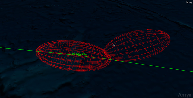
Intersecting Ellipsoids
Cleaning up your scenario
- Close the Close Approach By Min Range report.
- Close the Report & Graph Manager ().
Looking at the big picture
After analyzing a conjunction close up, it is a good to look at the big picture. You want to see all of the objects you initially considered in your analysis, including those objects which were eventually eliminated by your filters.
- Bring the 3D Graphics window to the front.
- Click Home View (
 ) in the 3D Graphics window toolbar.
 - Zoom out far enough that you can clearly see the geostationary belt.
- Select Normal Animation Mode (
 ) in the Animation toolbar.
 - Click Increase Time Step (
 ) to set the time step to 60.00 sec.
 - Click Start () to animate the scenario.
- When finished, click Reset ().
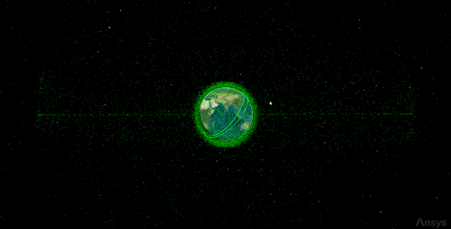
All ellipsoids
Wow! That is a busy scene! This view gives you an idea of what is in orbit. Remember that these satellites are only those that are publicly released: it does not include all satellites and debris. Also note that each green ellipsoid you are seeing is an order of magnitude larger than the object inside it. Still, space is a busy place!
Inserting a Facility object
Insert a Facility (![]() ) object which will function as the laser tracking facility.
) object which will function as the laser tracking facility.
- Insert a Facility (
 ) object using the Insert Default () method.
 - Right-click on Facility1 () in the Object Browser.
- Select Rename in the shortcut menu.
- Rename Facility1 () to LaserTrackingSite.
Using the LaserCAT tool
A variety of commercial and military operations involve the laser illumination of a satellite, missile, or launch vehicle from an Earth-based site. Such an illumination, known as lasing, may be used to provide precise range information or carry out data transfers to other satellites or ground facilities. However, lasing can pose a serious threat to other satellites. For example, sensitive satellite sensors can be damaged or even destroyed if inadvertently illuminated.
Use the LaserCAT tool to assess the potential of an unintended illumination of a satellite during a given lasing run or within a given lasing window.
- Select LaserTrackingSite () in the Object Browser.
- Open the Facility menu.
- Select LaserCAT....
- Select ISS_ZARYA_25544 () in the Pointing Method - Target Object list when the LaserCAT tool opens.
- Take a look at the other properties.
- You are evaluating any possible conjunctions with the entire satellite database. You could probably restrict this to only the active satellites and exclude the inactive ones and debris to reduce the number of objects you are concerned about.
- Keep the default values for the Laser Properties for now. You are looking for potential objects up to five (5) degrees away from the Facility-ISS vector, up to a 500,000 km range.
- Your analysis time period should cover the entire scenario interval.
- Click .
- Click in the Reports panel.
- Click .
The Clear Firing report indicates the time periods during which the safety cone is clear of potential victims. It is possible there may be no clear firing periods during your analysis interval.
The Potential Victims report lists each interval during the user-selected time period that the laser site had access to the target satellite, and indicates which potential victims entered the safety cone during those access periods.
Saving your work
- Close any open reports, properties and tools.
- Save () your work.
Summary
You were introduced to three STK Conjunction Analysis tools:
-
Launch Window Analysis tool
-
The Advanced CAT tool
-
The LaserCAT tool
You updated the local satellite database which uses TLEs. This is important because you used the database in your analysis. You used the Launch Window Analysis tool with a Launch Vehicle object to determine, during the next seven days, when it is safe to launch a satellite into space. Next, you propagated the ISS. Using the Advanced CAT tool, you determined if there were any potential conjunctions during the same seven-day period. Finally, you inserted an Earth-based facility which could laser illuminate the ISS over the same period. Using the LaserCAT tool, you determined that there were no good times to illuminate the ISS based on the default settings in the tool.