Great Arc Propagator
The Great Arc Propagator defines the route of a vehicle that follows a point-by-point path along, over, or below the surface of the Earth at a given altitude or depth. A great arc path, which lies in a plane that intersects the center of the Earth, connects the waypoints.
There are two general methods you can use to define a great arc route:
- Import a great arc file. STK will automatically update the waypoints table and altitude reference values with information from the file.
- Manually enter the properties of the route. You provide the waypoints, altitude reference, and all other values that define the route.
Importing a Great Arc file
Click to load waypoint data from an external Great Arc file, without using the StkExternal propagator.
Manually defining a route
To create a great arc route for the vehicle:
- Define the Start Time.
- Select a Route Calculation Method.
- Define the Altitude Reference.
- Define Waypoints.
Start Time
Start Time defaults to the scenario start time; you can reset it. The Stop Time field is read-only and is defined by the last waypoint for the vehicle. If you change Start Time after you enter waypoints, STK will automatically update all time entries in the waypoint table.
Click  or right-click the start or stop times to interact with the object time options.
Route Calculation Method
Use the Route Calculation Method shortcut menu to select the method for STK to use in calculating the route between each waypoint. The options are:
- Specify Rate/Acc uses the Speed and Acceleration properties of each waypoint.
- Specify Time uses the Time properties of each waypoint.
- Smooth Rate uses the Speed property of each waypoint.
Altitude reference
Ground vehicles, aircraft, and ships can reference their altitude from mean sea level, terrain data, or WGS84.
To have the route of a ground vehicle follow the terrain, set Altitude Reference to Terrain, Interp Method to Terrain Height, and the Altitude of all waypoints to 0.
Altitude Reference options for great arc vehicles
| Option | Value |
|---|---|
| Altitude Reference | You can set Altitude Reference to any of the following:
When a Great Arc vehicle uses an altitude reference of MSL, the altitude interpolator used by the Great Arc propagator will be set to MSL height. This interpolator linearly interpolates using an MSL reference rather than the ellipsoid reference. For arcs at constant MSL altitude, all interpolated points along that arc will also be at that same MSL altitude. The terrain data files available in this scenario for visualization and analysis are listed on the Terrain properties page. |
| Granularity | Granularity defines the distance between interpolation points for computing the vehicle's altitude along the route. |
| Interp Method | Interp Method sets the terrain interpolation method for STK to use to define the height of the vehicle with respect to terrain data.
When you select to use the terrain server (on the Scenario - Terrain page) as a terrain source, using the Terrain Height interpolator may result in STK making terrain server requests at all interpolated points. This is likely to slow performance compared to the case where the terrain is obtained only using local terrain files. Instead, you can try using a smaller granularity with the Ellipsoid Height interpolator as a compromise between performance and terrain accuracy. |
| Terrain Resolution | Displays the resolution of the terrain data used when referencing waypoint altitude to terrain. This value describes the distance between sampling points for the terrain data being used. Except in very rare circumstances, you should never set the Granularity to a smaller value than the Terrain Resolution, since this will result in the altitude being interpolated without valid reference points. |
Waypoints
The waypoints that comprise the great arc route are contained in a table that displays each point, along with all of its properties, in sequence. You can use the table to directly edit those properties. One row of values describes a single waypoint in the route of the vehicle.
Select the Update Map Graphics check box to display the ground track for the route in the 2D Graphics window as you enter and STK calculates new waypoints.
Adding a New Waypoint
There are two methods you can use to add a new waypoint to the route:
- Click to add a new line of data to the waypoint table after the currently selected row. The new waypoint's data will be a copy of the waypoint before it, if one exists. You can also use to insert a copy of the currently selected row.
- Click anywhere in the 2D Graphics window to add a new waypoint after the currently selected row. The new waypoint's latitude and longitude will be defined by the map point that you selected, while STK will supply the rest of the its properties by copying from the row above.
- If you use the 2D Graphics window method to define a great arc route, AGI recommends that you specify the altitude/depth, turn radius, and calculation method data for the first point before you create a second point, so that the initial altitude/depth and route data become the default for all additional waypoints.
- For more information on setting object properties using the mouse, see Mouse Shortcuts.
Modifying a Waypoint
There are two methods you can use to modify an individual waypoint in the route:
- Click the property of the waypoint that you want to modify in the table and enter a new value directly into the cell.
- Use the 2D Graphics window:
- Select the Clicking on map changes current point check box (beneath the waypoints table).
- Select the table row of the waypoint that you want to change.
- Click anywhere in the 2D Graphics window to redefine the latitude and longitude of the waypoint to the selected position.
The properties that you can define for a waypoint depend on the Route Calculation option that you have selected. The following table describes the properties that STK uses to define a great arc route waypoint. The Calculation Method column denotes which Route Calculation Methods enable you to edit that property.
Great Arc Waypoint Properties
You do not need to click or to save waypoints that you have inserted using the 2D Graphics window. You will, however, need to click or to save any other changes that you have made on the Basic Route Properties page, including waypoints that you manually inserted.
Modifying All Waypoints
Click to open the Set All Grid Values tool, which enables you to modify the Altitude, Speed, Acceleration, and Turn Radius properties for all waypoints that are currently defined in the table. The currently selected Route Calculation Method constrains the properties you can modify using this tool.
To use the tool, select each of the properties that you want to modify, enter the values that you want to set, and then click to implement the changes and close the window.
Removing Waypoints
To delete an existing waypoint, select the table row of the waypoint and click .
Arc Granularity
If you have specified an EGS84 or MSL altitude reference for the route, you can use the Arc Granularity field to specify the frequency of interpolated route points between the waypoints that you have specified. The lower the value, the smoother the route that STK will produce, at the expense of longer computation time.
Turns
The great arc path will never reach the given waypoint unless the change in heading The direction that the aircraft is pointing. is negligible. Instead, the turn will be inscribed between the lines connecting the previous procedure to the given waypoint and the waypoint to the next procedure. The position will arrive along the line from the previous procedure toward the given waypoint and leave along the line from the given waypoint toward the next procedure. The radius of the inscribed turn will be contained to the vehicle's radius. See the figure below for a visual representation of this.
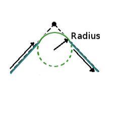
For great arc routes, STK computes turns using a constant velocity, as specified by the waypoint for which STK is generating the turn.