Access
Available Data Providers
| Name | Description |
|---|---|
| AER Data |
Provides azimuth, elevation, and range related information for the relative position vector between the base object and the target object. The information is available in a variety of coordinate axes. Reference Frames in AER ReportsAER reports for accesses are based on a default local coordinate system for every type of STK object. If the AER Report is based on a sensor, then the coordinate frame of the parent object is used. For facilities, places, and targets the local coordinate system is LH.
For aircraft, ships, and ground vehicles the local coordinate system is VVLH CBF (Central Body Fixed).
For satellites and missiles the local coordinate system is VVLH CBI (Central Body Inertial).
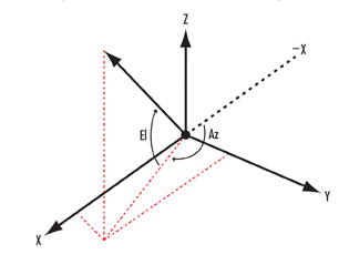
where, LH (Local Horizontal) X axis = constrained toward local north VVLH (Vehicle Velocity, Local Horizontal) X axis = constrained toward velocity vector How Azimuth and Elevation are DefinedThe following frames are used in defining azimuth (Az) and elevation (El): Vehicle Velocity Local Horizontal (VVLH) coordinate system
Local Horizontal (LH) coordinate system
Topocentric coordinate system
Topocentric System
VVLH & LH Systems
For more information, see Access Tool. |
| AER Reference Frame Info | Reports the name of the reference frame used when using the AER data provider to report in its Default frame. Also reports the reference object used that defines the frame. |
| Access Data | Reports information concerning the start and stop time of each access interval. |
| Access Gaps | Reports intervals where access does not exist between the objects. |
| Access Intervals by Constraint | Reports the intervals satisfying each constraint in the constraint set computed for the access, in the order in which the constraints were applied. |
| Access Intervals by Time | Reports the intervals satisfying each constraint in the constraint set computed for the access, in the order of the satisfaction intervals of each constraint. |
| Access Schedule | Reports access intervals in a format that can be import by Microsoft Scheduler+. All fields are declared unitless and are returned as strings. |
| Active Constraints | Lists the constraints that are applied when computing the access. |
| All Boundary Access | Reports the access time intervals when all of the AreaTarget/LineTarget's boundary points have access simultaneously. One object used in the access must be an AreaTarget or LineTarget. |
| Allowed Times | Reports the time intervals over which access between the two objects (Base and Target) may be computed and the availability intervals for these objects. |
| Angles | Reports angle and its time rate of change rate. Angle must be defined in the Vector Geometry Tool. |
| Area Collection Angle | Reports the access time intervals and the collection angle at the point of closest approach to the AreaTarget centroid during each interval. One of the objects must be an AreaTarget. |
| Axes Choose Axes | Reports the orientation and angular velocity of the selected set of axes relative to a chosen reference set of axes. The selected set of axes can be selected from any axes in the Vector Geometry Tool owned by the object; the reference axes may be chosen from any axes in the Vector Geometry Tool. |
| Boundary Minimum Range | Reports the time of minimum range from each boundary point of an AreaTarget/LineTarget to the other access object. |
| Boundary Point Access | Reports access intervals for each boundary point of an AreaTarget/LineTarget. |
| Boundary Target Data | Reports down track and cross track range over time for each boundary point of the AreaTarget/LineTarget for an
access involving the AreaTarget/LineTarget and a moving object (or sub-object). The range measures make use of the moving object's reference plane,
defined as the plane containing the position vector of the moving object and its velocity vector measured with respect to the object's central body fixed system.
While allowed, the data obtained when the From object is not moving is not informative. |
| Collection of Interval Lists | A time component that produces a collection of related interval lists. |
| Comm Active Prop Models | Active propagation models |
| Comm VOACAP Files | Provides the user with the ability to display or save off a VOACAP formatted circuit definition input file, transmit antenna definition input file, receiver antenna definition input file, and/or the VOACAP output file. The Pre-Data Dialog will prompt the user with the ability to display the files for a particular moment in time as well as provide the user with the option to have these files saved off. If the user selects the option to save the files, they will be saved off in corresponding sub-folders within the scenario directory. |
| Condition | Reports the value of selected scalar conditions. The scalar condition must be defined in the Calculation Tool and owned by the object. |
| Condition Set | Defines a set of conditions for when the elapsed time falls within specified time limits. |
| Configuration | Reports access computational settings. |
| Considered Times | The time intervals over which access was computed. |
| Constraint Data | Reports constraint data available for the access pair. |
| Constraint Sample Stats | Reports statistics of the sampling applied for each constraint of the access. |
| Constraint Samples | Reports constraint sampling. |
| Crdn Available Times | Time intervals for which a Vector Geometry Tool component for the object is available. |
| Event Times | Reports events during each access interval. |
| From Position Velocity | Reports position and velocity information of the base object with respect to its central body.
Planets report position and velocity with respect to the Sun. |
| Interval | A time component that produces a single interval of time. |
| Interval List | A time component that produces an ordered list of time intervals. |
| LLA Grazing Point | Reports the grazing point along the line of the sight between the objects involved in the access (i.e., the closest point to the central body ellipsoid along the line segment between the objects). The location is expressed in detic coordinates. |
| LLR Grazing Point | Reports the grazing point along the line of the sight between the objects involved in the access (i.e., the closest point to the central body ellipsoid along the line segment between the objects). The location is expressed in centric coordinates. |
| Link Information | Link information provides the link budget for a single access between a transmitter and a receiver. |
| Link Information - VOACAP | Provides the user with additional link information Report Elements. These are report elements that pertain to the sky-wave propagation path direction rather than the straight-line path direction. The report elements associated from the transmit antenna through the propagation channel and to the receive antenna should be utilized in typical OTH HF link budgFets reporting (e.g. transmit angles/gains, propagation loss/ranges, receive angles/gains). NOTE: When using the VOACAP model, there are several Link Information Data Provider report elements which are of little importantance. These include Xmtr Azimuth, Xmtr Elevation, Xmtr Gain, Free Space Loss, Rcvr Azimuth, Rcvr Elevation, Rcvr Gain, Range. These are considered "Straight-line path" report elements and are of little use for over the horizon (OTH) analysis. Rather than using these "straight-line path" report elements in your reports, you can consider using the "Skywave path" versions, which are located below. They are called Transmit Azimuth, Transmit Elevation, Transmit Gain, Skywave Free Space Loss, Receive Azimuth, Receive Elevation, Receive Gain, Skywave Range. The Link Information Data Provider's report element called Free Space Loss is reported as zero because the Skywave Free Space Loss is included in the calculation of total propagation loss as reported by the PropLoss report element. |
| Parameter Set: Attitude | The Attitude parameter set defines orientation of one set of Axes from VGT relative to another. This parameter includes the following sub-sets: Quaternion, Euler, DCM and AngleAxis. Quaternion includes four quaternion elements Q1, Q2, Q3, Q4. Euler includes all 12 sequences where within each there are three angles: A, B, C. DCM includes all nine elements of the direction cosine matrix; e.g., XX, XY, etc. AngleAxis includes X, Y, Z components of the unit axis of rotation and RotationAngle. |
| Parameter Set: Cartographic Trajectory | Cartographic Trajectory Parameter Set contains calculations that relate a specified point to the selected central body shape. This parameter set contains the following sub-sets: Cartesian, Centric and Detic. Cartesian includes X, Y, Z and Radius. Centric includes LLR with Latitude, Longitude and Radius, and SubPoint with Cartesian elements. Detic includes several LLA with Latitude, Longitude, Altitude, SurfaceNormal with Cartesian elements without Radius, and SubPoint with Cartesian elements. It also includes Terrain and MSL both with LLA and SubPoint subsets of their own. |
| Parameter Set: Comm Link Information | Computes the communication link budget elements following the signal flow. It starts from the RF transmitter and follows through the link stages, such as the transmitting antenna, RF propagation environments, receiving antenna, and the receiver system. Each line of the link report corresponds to a time step. The link budget data elements are organized by the report style used to create the report. |
| Parameter Set: Orbit | The Orbit parameter set defines orbital element sets for a Point from VGT orbiting the specified Central Body in the specified coordinate System. Element sets include: Cartesian, Classical, Delaunay, Spherical and Equinoctial (Posigrade and Retrograde). |
| Parameter Set: Radar Antenna | Below are the parameter sets that apply to radar antennas. |
| Parameter Set: Radar SAR | Synthetic Aperture Radar (SAR) spot light model. |
| Parameter Set: Radar Target RCS | Target to Radar transmitter direction azimuth angle around the reference axis in the target's body frame. |
| Parameter Set: Trajectory | The Trajectory parameter set defines the position of a specified Point from VGT with respect to the reference System. This parameter set includes the following sub-sets: Cartesian, Cylindrical and Spherical. Cartesian includes X, Y, Z and Radius. Cylindrical includes Azimuth, Height, Radius. Spherical includes Azimuth, Elevation, CoElevation, and Radius. |
| Parameter Set: Vector | The Vector parameter defines the position of one access object relative to the other. The position data can be reported in multiple different reference frames. |
| Planes Choose System | Reports the selected plane and its velocity in a specified reference coordinate system. Both plane and coordinate system must be defined in the Vector Geometry Tool. |
| Planes(Fixed) | Reports the selected plane and its velocity in the object's central body fixed coordinate system. The plane must be defined in the Vector Geometry Tool. |
| Planes(ICRF) | Reports the selected plane and its velocity in the object's central body ICRF coordinate system. The plane must be defined in the Vector Geometry Tool. |
| Planes(Inertial) | Reports the selected plane and its velocity in the object's central body inertial coordinate system. The plane must be defined in the Vector Geometry Tool. |
| Planes(J2000) | Reports the selected plane and its velocity in the object's central body J2000 coordinate system. The plane must be defined in the Vector Geometry Tool. |
| Points Choose Plane | Reports projection of the selected point and its velocity on a specified reference plane. Both point and plane must be defined in the Vector Geometry Tool. |
| Points Choose System | Reports the selected point and its velocity in a specified reference coordinate system. Both point and coordinate system must be defined in the Vector Geometry Tool. |
| Points(Fixed) | Reports the selected point and its velocity in the object's central body fixed coordinate system. The point must be defined in the Vector Geometry Tool. |
| Points(ICRF) | Reports the selected point and its velocity in the object's central body ICRF coordinate system. The point must be defined in the Vector Geometry Tool. |
| Points(Inertial) | Reports the selected point and its velocity in the object's central body inertial coordinate system. The point must be defined in the Vector Geometry Tool. |
| Points(J2000) | Reports the selected point and its velocity in the object's central body J2000 coordinate system. The point must be defined in the Vector Geometry Tool. |
| Radar Active Prop Models | Active propagation models |
| Radar Antenna | Below are the parameter sets that apply to radar antennas. |
| Radar Environment | Computes the RF signal losses due to the signal propagation environments from the radar transmitter to the target and from the target to the radar receiver. |
| Radar Environment - VOACAP | Provides the user with additional radar forward and return link information Report Elements. These are report elements that pertain to the Skywave propagation path direction rather than the straight-line path direction. The report elements associated from the transmit antenna through the propagation channel and to the target antenna, and from the target through the propagation channel and to the receiver should be utilized in typical OTH HF radar reports (e.g. transmit angles/gains, propagation loss/ranges, receive angles/gains). |
| Radar Geometry | Computes the positions, velocities, and attitudes of the radar and target objects. It also computes the geometric relationships between the radar transmitter and the target, and between the target and the radar receiver. All geometric computations account for the light speed delay of the signal propagation. |
| Radar SAR | Synthetic Aperture Radar (SAR) spot light model. |
| Radar VOACAP Files | Provides the user with additional link information Report Elements. These are report elements that pertain to the sky-wave propagation path direction rather than the straight-line path direction. The report elements associated from the transmit antenna through the propagation channel and to the receive antenna should be utilized in typical OTH HF link budgFets reporting (e.g. transmit angles/gains, propagation loss/ranges, receive angles/gains). NOTE: When using the VOACAP model, there are several Link Information Data Provider report elements which are of little importantance. These include Xmtr Azimuth, Xmtr Elevation, Xmtr Gain, Free Space Loss, Rcvr Azimuth, Rcvr Elevation, Rcvr Gain, Range. These are considered "Straight-line path" report elements and are of little use for over the horizon (OTH) analysis. Rather than using these "straight-line path" report elements in your reports, you can consider using the "Skywave path" versions, which are located below. They are called Transmit Azimuth, Transmit Elevation, Transmit Gain, Skywave Free Space Loss, Receive Azimuth, Receive Elevation, Receive Gain, Skywave Range. The Link Information Data Provider's report element called Free Space Loss is reported as zero because the Skywave Free Space Loss is included in the calculation of total propagation loss as reported by the PropLoss report element. |
| Refraction | Reports information of the effects of refraction on elevation angle, range, and propagation delay. |
| Rel Position Velocity | Reports the apparent relative position and velocity, as viewed from the base object, expressed with respect to the base object's central body.
Planets report position and velocity with respect to the Sun. |
| Sat Angles Data | Reports angles to the target object from the base object of an access, with respect to the base object's local CBI VVLH frame (i.e., VVLH axes based on the CBI velocity of the base object). |
| Scalar Calculations | Calculation component that produces scalar time-varying calculations. |
| Sensor Based Angles | Reports the apparent angles to the target object from the base object, using the BodyFixed frame. |
| Targeting Data | Reports several range measures of the relative position between the objects. Several measures use the
From object's reference plane, defined as the plane containing the position vector of the From object and its velocity vector measured
with respect to the From object's central body fixed system. While allowed, the data obtained when the From object is not moving is not informative. |
| Time Array | A time component that produces intervals of time within which there are ordered arrays of times. |
| Time Instant | A time component that produces a single moment in time. |
| To Position Velocity | Reports the apparent position and velocity information of the target object as observed from the base object, expressed with respect to the base object's central body.
Planets report position and velocity with respect to the Sun. |
| Vector Choose Axes | Reports the selected vector and its derivative in a specified reference set of axes. Both vector and axes must be defined in the Vector Geometry Tool. |
| Vector Choose Plane | Reports projection of the selected vector and its derivative on a specified reference plane. Both vector and plane must be defined in the Vector Geometry Tool. |
| Vectors(Fixed) | Reports the selected vector and its derivative in the object's central body fixed axes. The vector must be defined in the Vector Geometry Tool. |
| Vectors(ICRF) | Reports the selected vector and its derivative in ICRF axes. The vector must be defined in the Vector Geometry Tool. |
| Vectors(Inertial) | Reports the selected vector and its derivative in the object's central body inertial axes. The vector must be defined in the Vector Geometry Tool. |
| Vectors(J2000) | Reports the selected vector and its derivative in J2000 axes. The vector must be defined in the Vector Geometry Tool. |